
Property Easements Explained for Birmingham Landowners
If you own property, there is a good chance an easement runs across part of it. Many owners never find out until they try to build, sell, or dispute access with a utility company. Knowing what easements are, how they work, and how an easement survey documents them can protect your land from costly surprises.
What Is an Easement?
An easement gives someone other than the owner the right to use part of a property for a set purpose. The owner keeps the land. The easement holder gets a limited right to use that part of it.
In Alabama, an easement is a non-possessory interest in real property. The holder does not own the land. They only have the right to use it for the purpose the agreement describes or the law establishes.
Most easements are permanent. They stay attached to the property when ownership changes. A buyer who skips checking for easements before closing can inherit restrictions they never agreed to.
Common Types of Easements
Utility easements are the most common type. They let power companies, water authorities, gas providers, and telecom companies install and maintain lines across private land. Landowners with utility easements cannot build over the corridor or block access to the equipment.
Access easements, also called right-of-way easements, let a person or the public cross one property to reach another. They are common when a parcel has no direct road access. Alabama law recognizes that landlocked owners have the right to reach a public road through neighboring land.
Drainage easements give a municipality or neighboring property the right to direct water across a parcel. They are common near creeks, ditches, or storm drainage systems. Building within a drainage easement can block water flow and cause legal problems.
Prescriptive easements are different. They are not written agreements. They arise when someone uses part of your land openly and continuously, without your permission, for long enough. In Alabama, that period is 20 years under Alabama Code Section 6-5-200. If someone crossed a corner of your land for two decades and you never stopped them, they may have gained a legal right to keep doing so.
How Easements Are Recorded and Found
Most formal easements in Jefferson County are recorded at the Jefferson County Probate Court. The Probate Court Land Records office keeps easement deeds, right-of-way agreements, and subdivision plats that affect real property.
When a title search is done before a sale, recorded easements should appear. But not every easement shows up in a title search. Prescriptive easements and easements by implication may not be written down anywhere. They can exist based on how the land has been used over time, with nothing in the probate records.
That is where an easement survey becomes important.
What an Easement Survey Does
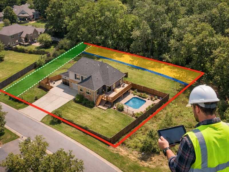
An easement survey is performed by a licensed land surveyor. It locates and maps recorded easements on the ground, showing exactly where they fall within the property’s boundaries.
The surveyor reviews easement documents from the probate records, then visits the property. They look for physical evidence such as utility poles, buried line markers, drainage structures, or worn paths. They measure the width and position of each easement corridor and show it all on a survey map.
That map tells you where you can and cannot build, place structures, or make improvements. A document tells you an easement exists. A survey tells you exactly where it sits on your land.
Why Easements Matter Before You Build or Buy
A fence, shed, or addition placed inside a utility or drainage easement can be required to come down at your expense. The easement holder has the right to remove anything that blocks their access. A survey done before construction prevents that situation.
When buying property, knowing where easements are affects how you plan to use the land. An easement through the middle of a lot limits where a house can sit. A drainage easement along the rear may rule out a pool or garage. A title report alone may not show this clearly. A field survey shows the physical reality.
Easements also affect property value. A parcel with a large utility corridor running through it has less usable area than the lot size suggests. Knowing this before a transaction protects buyers and sellers.
Frequently Asked Questions
Can an easement be removed from my property?
In Alabama, easements can end in a few specific ways. If one person comes to own both the land the easement benefits and the land it crosses, the easement ends by merger. An easement by necessity ends when the need is gone, such as when a new road gives a landlocked parcel access. Ending an easement by abandonment requires clear evidence of intent to give up the right. Not using it for a period of time is generally not enough.
Does a recorded easement always show up in a title search?
Not always. Recorded easements in Jefferson County are kept at the Probate Court and should appear in a standard title search. Prescriptive easements and easements by implication may not be in the written record at all. A field survey by a licensed surveyor is the most reliable way to find all easements on your property.
Can I build a fence across a utility easement?
Generally, no. Most utility easements prohibit structures that block access to the corridor. Some allow a fence with a gate the utility company can open, but that depends on the specific easement terms. Building across a utility easement without reviewing those terms first creates legal and financial risk.
What is the difference between an easement and a right of way?
A right of way is a type of easement. It grants the right to travel across a piece of land. All rights of way are easements, but not all easements are rights of way. Utility, drainage, and conservation easements are other types that do not involve crossing the land.
How does an easement survey differ from a boundary survey?
A boundary survey establishes the legal limits of a property. An easement survey locates and maps the recorded easements within those limits. It shows where each corridor sits on the ground. Both are done by licensed land surveyors but serve different purposes. Many landowners need both when planning construction or a property transaction.